Researchers at Yale University, a prestigious educational institution in the USA, examined a map believed to be from the 15th century. As a result of the examinations made on the map showing the Vikings’ explorations in North America, it turned out that the map was fake.
A map of the Vikings’ explorations of North America, believed to be from the 15th century. It turned out to be fake. The aforementioned situation was discovered by researchers at Yale University in the USA.
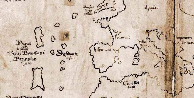
Map showing the portion of the continent’s coastline called the “Vinlanda Insula”, Vikings arrived in North America before Christopher Columbus It had a great impact when it appeared because it added weight to his thinking.
The map was scanned with high-tech tools:
Although Yale University, one of the respected educational institutions of the USA, took this map and made it public in 1965, suspicions that the map was fake still existed. Also, researchers from Yale University, in a recent study, X-ray fluorescence spectroscopy (XRF) and field emission scanning electron microscope He scanned the map from beginning to end with high-tech vehicles called (FE).
Radiocarbon dating analysis of the parchment indicated that it dates from 1400 to 1460 AD. This analysis was consistent with the findings of previous studies on the map. However, according to new research, The ink was definitely not old.
The ink on the map is different from the ink found on the maps of the period.
Writers and cartographers of the Middle Ages; he used an ink made from ferrous sulfate and powdered oak nut. The ink in the lines and text on the Vinland Map is almost instead of iron or sulfur It contained a lot of titanium.
Researchers who also analyzed dozens of manuscripts from the 15th century found that they were more than those found on the Vinland Map. much lower level He found that titanium and much higher levels of lead were found.
RELATED NEWS
Earth’s Northernmost Island Accidentally Discovered: It Could Be Deleted from the Map
In addition, the titanium compound, which dominates the entire map, was first used in inks produced in the 1920s. Further analysis also revealed that the ink on the map was produced in Norway in 1923. Raymond Clemens, curator of the Kniecke Rare Books Library at Yale University,The Vinland Map is fake. There is no reasonable doubt about this. This new analysis should put an end to the discussion.” said.
Source :
https://www.indyturk.com/node/417421/bi̇li̇m/ünlü-viking-haritasın-gizemi-solved-tamamen-fake