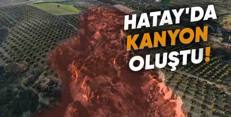
The huge canyon-like rift that formed in an olive grove in Hatay’s Tepehan village right after the earthquake was imaged with a drone. The rift, stretching for hundreds of meters, has turned the once lush land into a ruin.
held on February 6, 9 hours apart. 7.7 And 7.6 Two earthquakes of magnitude suffocated Turkey with deep mourning. The earthquake, in which we lost tens of thousands of lives, not only destroyed our homes with its gigantic jolt, but also smashed our roads and bent and twisted the railways as if they were a plastic cable.
One of the most terrifying sights of the earthquake appeared in an olive grove in the Tepehan village of Hatay. The olive grove stretching for hundreds of meters was literally torn like paper during the earthquake. Hundreds of meters of crevice In the middle of the olive grove that has formed, a canyon has formed.
Satellite image of the olive grove in Tepehan village before and after the earthquake:
In the photo above, you can see the collapsed region before the earthquake. This olive grove, which looks like a natural wonder and where the greenery extends from one end to the other, has turned into a place that does not look like disaster movies after the earthquake. The photo below shows the condition of the area after the earthquake.
As you can imagine, the rift and depression in question emerged when the Eastern Anatolian fault, which caused the Kahramanmaraş earthquake, caused a surface rupture in the region. In the statements made after the earthquake, in the region where the fault was broken, the Anatolian plate shifted towards the Arabian plate. moves close to 3 meters had been expressed.