The north was particularly hard hit by the storm.
(Photo: dpa)
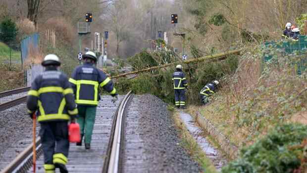
Berlin Due to storm damage, rail travelers must continue to expect train cancellations and delays. There is currently still damage on more than 1000 kilometers of track, the railway said on Sunday morning. There will be severe impairments until at least Monday afternoon.
Around 2,000 emergency services are on duty around the clock to remove fallen trees and repair overhead lines. The train service should be increased step by step, the railway announced.
In long-distance traffic, there were still significant problems, especially in northern Germany on Sunday. According to the railways, regional traffic could be resumed on most of the affected routes.
In long-distance traffic, individual ICE trains are traveling between Berlin via Hanover to North Rhine-Westphalia. There are also individual trains on the Munich, Hanover, Bremen and Hamburg routes. According to Deutsche Bahn, the Berlin – Leipzig/Halle (Saale) route has been free again since Saturday evening.
Top jobs of the day
Find the best jobs now and
be notified by email.
Deutsche Bahn advised passengers to avoid traveling to the affected regions, especially to Hamburg. Before starting the journey, she recommended getting information from the free special hotline on 08000 99 66 33.
“We have to get through the storm situation until Monday”
Even on Sunday, the heavy storms and sometimes hurricane-force gusts are not over. “We still have to get through the storm situation until Monday,” said a meteorologist from the German Weather Service (DWD) in Offenbach.
After hurricane “Zeynep”, the wind from storm “Antonia” is already picking up and can cause dangerous storms, especially on Monday night. The weather only calmed down in the evening.
“It gets interesting from 9 p.m. on Sunday evening,” says the meteorologist. Then the wind will increase again significantly and move through the country from north-west to south-east in connection with a cold front.
In the meantime, there is a risk of violent storms and hurricane-force gusts with wind speeds of up to 115 km/h. Heavy showers and thunderstorms are to be expected. Hurricane-like gusts on the Baltic Sea can last until Monday morning. Above the middle, however, the danger of severe gusts of wind is not quite as high.
Weather relaxation from Tuesday
In the morning the cold front reaches the foothills of the Alps. Especially in southern Bavaria, hurricane-like gusts cannot be ruled out. At noon the storm calmed down a bit. “But Monday will also be a windy, stormy day with lots of rain,” says the meteorologist. Snow falls above 400 to 600 meters. The maximum temperatures are between 5 and 11 degrees, in the mountains it stays a little cooler.
Towards evening the wind will be noticeably slowed down and from Tuesday the situation will relax significantly. “The wind will remain an issue throughout the week,” said the meteorologist. “However, it will be a completely different house number than what we are experiencing these days.”
More: Deutsche Bahn was significantly less punctual in 2021 than in 2020