Google Maps images show how the southern Ukrainian city was leveled by Russia.
(Photo: Google Earth)
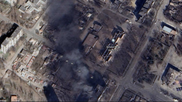
Mariupol Puffs of smoke, debris and black areas: New satellite images from the map services Google Earth and Google Maps give a rare insight into the extent of the destruction of the Ukrainian port city of Mariupol. Previously, the service provider updated its images in June 2021, before the start of the full-scale invasion of Russia.
Russian troops besieged the city from the first day of the war. The city has been under complete Russian control since the last defenders of Ukraine’s Azov Battalion gave up their resistance in May 2022. Only a few pieces of information, pictures and reports are leaked from the crew.
houses without roofs
The Google satellite images therefore help to better assess the extent of the destruction in Mariupol. According to the pictures, the city center was hit particularly hard: some streets there appear black as a result of Russian rocket attacks. In some cases, entire blocks of houses can be seen without roofs, such as on Arkhip Kuindzhi Street.
The destruction in the area of Arkhip Kuindzhi Street.
(Photo: Google Earth)
A steel mill in ruins
Read on now
Get access to this and every other article in the
Web and in our app free of charge for 4 weeks.
Further
Read on now
Get access to this and every other article in the
web and in our app.
Further