The size of the Kahramanmaraş-centered earthquakes was viewed from space. US Aerospace Agency (NASA) recorded images after the earthquake. Kahramanmaras And Gaziantep revealed the change in the maps of cities such as
NASA and space organizations shared the earthquake map
Earthquakes, which caused widespread destruction in southern Turkey, claimed many lives. The depth of the initial 7.8 quake, along with the aftershocks that followed, caused significant damage to homes and infrastructure in the area. NASA and other space agencies viewed this damage from satellites.
The Singapore Earth Observatory Remote Sensing Laboratory, NASA’s Jet Propulsion Laboratory, and the Advanced Rapid Imaging and Analysis (ARIA) team at Caltech collaborated to create a map of the affected areas. Map of Japan with radar sensor ALOS-2 satellite It was created from data collected by on February 8, 2023.

Countries and numbers participating in earthquake search and rescue efforts: The whole list!
After the earthquake in the Southeast Anatolia region, search and rescue teams from all over the world participated in the work. Here are those countries…
The satellite’s observations were compared with previous data dated April 7, 2021 and April 6, 2022 to identify areas likely to be damaged by earthquakes. Looking at the photos, Turkey’s Islahiye, Kahramanmaraş and Nurdagi areas are found to be severely damaged.
Red pixels on the map indicate heavily damaged areas. Orange and yellow pixels represent moderately and partially damaged areas, respectively. Each pixel is about 30 meters in size.
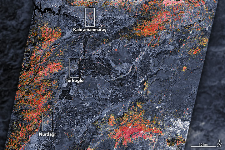
According to NASA’s statement, the damage representation map provides critical information for disaster response efforts. This allows authorities and aid organizations to put things in order and use resources more effectively.