In several countries in northern and western Europe, the hurricane caused strong gusts of wind, train cancellations and closed ports.
(Photo: Reuters)
Berlin,London In view of the storm “Zeynep”, Deutsche Bahn advises passengers to bring forward their trips planned for late Friday afternoon as far as possible. “Substantial disruptions to rail operations are to be expected from the afternoon hours,” the company said on Friday in Berlin. Then the next storm front will reach Germany. It has not yet been announced whether, when and where operations will be discontinued.
The railway is gradually discontinuing regional traffic in parts of northern Germany and North Rhine-Westphalia due to the announced storm. The company announced this for the course of the day in Schleswig-Holstein, Lower Saxony, Hamburg, Bremen and parts of NRW.
Long-distance traffic is also to be phased out. For the rest of the day, there will be no more long-distance trains north of Dortmund, Hanover and Berlin, the company said. No long-distance trains ran all day on the connections from Amsterdam to Berlin and Frankfurt.
The protection of travelers and employees has priority, it said. The German Weather Service warns of severe weather with extreme hurricane gusts and hurricane-like gusts, especially for the northern parts of the country and for central Germany from the afternoon.
Top jobs of the day
Find the best jobs now and
be notified by email.
“Whoever can, we recommend traveling by train from the late afternoon to an earlier time,” recommended the railway. Passengers can use their tickets booked for the period from Thursday to Sunday flexibly until February 27 or cancel free of charge if they postpone trips because of the storm.
From Friday afternoon, the storm “Zeynep” will cause considerable disruption to rail traffic, especially in northern Germany and North Rhine-Westphalia.
(Photo: imago images/Hanno Bode)
With the new storm low, wind speeds that are sometimes significantly higher than on Thursday with hurricane low “Ylenia” can be expected. During the storm, the railway temporarily stopped operating in northern Germany on Thursday morning. According to the company, four fifths of the long-distance trains are now running, and 80 percent of the stops are on time.
>> Read about this: When insurance companies pay for storm damage
The consequences of hurricane “Ylenia” are still visible in northern Germany. After the storm on Thursday, the fish market in Hamburg’s Altona district was flooded again early Friday morning. According to the Federal Maritime and Hydrographic Agency (BSH), the water level at the St. Pauli measuring point was 1.49 meters above the mean high water level – one centimeter below the limit for storm surges.
The fish market on the Elbe was flooded on Thursday.
(Photo: dpa)
For Saturday, the BSH expects water levels of up to three meters above the mean high water, which corresponds to a severe storm surge. The maximum is expected to be reached early Saturday morning.
VW is cutting shifts in Emden
In order to avoid damage and accidents, citizens should make appropriate preparations before the next storm. “Everything that is on the terrace that is not nailed down is best brought in and put in the garage,” said Christopher Rehnert, head of the Lüdenscheid fire brigade, on Friday morning in the ARD “Morgenmagazin”. Flower boxes or other items should be removed from balconies.
Because of the approaching hurricane, Volkswagen is temporarily suspending production at its Emden plant. A VW spokeswoman confirmed a corresponding report by the “Emder Zeitung” on Friday afternoon.
Accordingly, the late and night shifts were canceled on Friday. Employees were asked to stay at home. This happens out of caution, said the VW spokeswoman. The aim is to protect employees from the storm on their way to and from the plant.
On Saturday, the early shift was also supposed to start work a little later. It was not known how many workers were affected. A total of around 9,000 people work at VW in Emden.
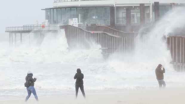
Hurricane hits Great Britain
Stormy weather partially paralyzed public life in Great Britain on Friday and caused destruction. In London, the highest red warning level was declared for the first time. It also applied to parts of South West and South East England and Wales. Mayor Sadiq Khan urged people in the British capital to stay at home. The Met Office warned that there was a risk of death from flying debris.
Videos circulating on the internet showed how the covering of the Millennium Dome in the London Borough of Greenwich was partially torn away. Underneath the tent-like construction erected at the turn of the millennium is the O2 Arena, which often hosts music and sporting events. Train services in London have been partially suspended.
The gusts of wind damaged the roof of the Millennium Dome event venue.
(Photo: Reuters)
Storm “Eunice”, which was christened “Zeynep” in Germany, is considered one of the most severe storms in Great Britain in several decades. The highest wind speed ever measured in England was registered on the Isle of Wight at around 196 kilometers per hour, according to the weather service.
Dozens of flights have been canceled at Heathrow Airport and London City Airport. The Port of Dover has been closed following a string of ferry services. Several national rail operators also advised against travel. In Wales, train services were completely suspended on Friday.
Tens of thousands of homes across the UK and Ireland were left without electricity. Roads and bridges were closed. Despite this, there have been reports of people getting dangerously close to shore defenses or even swimming into the sea. That’s “probably the stupidest thing you can do,” said Roy Stokes of the Environment Agency, according to the PA news agency.
Storm “Dudley”, which is called “Ylenia” in Germany, had already led to serious disruptions in train traffic in Scotland and the north of England on Thursday night. Thousands of homes across the north of England have been left without electricity.
France warns of four meter high waves on the coasts
France and the Netherlands are also preparing for the approaching storm. In France, the weather service has issued a severe weather warning for five departments in the north. Wind speeds of up to 140 kilometers per hour and waves up to four meters high on the coast threatened, the weather service said on Friday morning.
In the Netherlands, the most severe level of the weather alarm, code red, applies to large parts of the country. The weather service KNMI warned on Friday of “dangerous situations” caused by very heavy gusts of wind with speeds of up to 130 kilometers per hour.
The French railways announced that they would stop regional traffic in the north and in Normandy from midday, with a few exceptions. Disabilities were also expected in eastern France. The TGV trains should run as planned, but the high-speed Thalys not to the Netherlands.
In the Netherlands, the weather alert applies in particular to the coastal provinces in the west, the north and the regions around the IJsselmeer and the Wadden Sea. From around 2 p.m. the storm will reach the Netherlands. In the evening, the wind will then weaken, as the experts estimate. As a precaution, train traffic should be stopped after 2 p.m., many schools will be closed. Impairments were also expected for air traffic: Amsterdam Airport Schiphol announced cancellations and delays. Because of the storm, many vaccination and test centers should also be closed in the afternoon.
Hurricane “Ylenia” led to thousands of operations
Hurricane low “Ylenia” had already led to thousands of operations since Wednesday evening. Many trees fell, there were accidents on the roads with some dead and injured, and rail traffic in the north came to a standstill in large parts. The Berlin fire brigade alone deployed around 1,300 missions by Thursday evening.
At least three drivers in Lower Saxony and Saxony-Anhalt died in weather-related accidents – two were killed by falling trees, a third died when his trailer got into the oncoming lane in a storm and an accident occurred.
An incident for the people on a Hamburg harbor ferry went off lightly: On a stormy trip across the Elbe on Thursday morning, a large wave smashed the front windows of the ship. According to police, three passengers suffered minor injuries.
“Ylenia” sets a wind power record
According to an analysis by the energy company Eon, the storm caused a wind power record. On Wednesday, with a peak of 47.12 gigawatts, more wind power was fed into the German power grid than ever before, Eon reported on Friday in Munich after evaluating data from the Federal Network Agency. The new high was reached on Wednesday evening.
According to the information, the wind power record is the peak of several windy weeks at the beginning of the year: by February 17 alone, German wind turbines on land and at sea generated more than 28 billion kilowatt hours of electricity. In the previous year, only around 18.5 billion kilowatt hours had come together up to this day.
With a view to the weather forecast, the Eon analysts estimate that a total of more than 37 billion kilowatt hours of wind power could be generated in Germany in January and February. For comparison: In the whole of 2021, the systems in Germany generated around 118 billion kilowatt hours of wind power.
Eon registered the largest share of wind power in electricity consumption so far this year on February 6th, a Sunday when electricity consumption is lower than on weekdays. The average value for January was a good 36 percent. In February, the average so far is over 50 percent wind power.
More: Violent storm moves over Germany – pictures of the storm