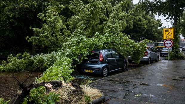
A fallen tree on a car. Due to a storm, there are massive traffic delays in the Netherlands.
(Photo: dpa)
Amsterdam, Hamburg Heavy storms severely affected air and rail traffic in the Netherlands on Wednesday. Around 300 flights have been canceled at Schiphol Airport in Amsterdam, one of the most important hubs in Europe, the ANP news agency reported.
The railway operator NS stopped all train traffic in the north of the Netherlands. The weather service issued the highest warning level for large parts of the country.
Wind speeds of 100 to 120 kilometers per hour are expected, and warnings have been given of falling trees and objects flying around. The traffic authorities also warned against driving on the motorways, where there have already been reports of trucks being blown over and trees falling in the lanes. Citizens were asked to stay in their homes.
School failure in parts of Lower Saxony
Germany is also preparing for the storm “Poly”. The German weather service calls for avoiding unnecessary car trips on Wednesday and securing wind-prone objects. The severe weather warning is in effect from 11 a.m. in the morning until 8 p.m. in the evening.
In Lower Saxony, lessons are canceled due to possible storms. In Delmenhorst, classes at general and vocational schools were canceled from 10 a.m., as a spokesman for the traffic management center confirmed. In the city of Oldenburg, there should also be no classes from 10 a.m. at general and vocational schools that are sponsored by the city.
In Hamburg, the Ohlsdorf, Öjendorf, Volksdorf and Wohldorf cemeteries were closed from 12 p.m. due to the storm and hurricane warnings. According to the cemetery administration, all funeral services have been cancelled.
According to the German Weather Service (DWD), the low will bring a lot of rain and gusts of wind to Germany over the course of the day. The rain area therefore moves from west to east and south-east. Heavy thunderstorms with heavy rain are also possible, as the DWD announced in Offenbach on Tuesday. In addition, there is increasing wind, in the east and the northern low mountain ranges heavy gusts of wind must be expected. Hurricane gusts are also possible.
Weather service warns of hurricane gusts
“The focus of the wind development is indicated for the North Sea and the adjacent inland from East Friesland to the northern half of Schleswig-Holstein,” said the DWD. There is a risk of hurricane-like gusts or hurricane gusts from late Wednesday morning until the evening.
The DWD warned that in the north and north-west, obstructions on roads and rails due to falling trees or breaking branches are likely. This also applies in view of the considerable damage to the trees in some areas due to the drought, explained DWD meteorologist Sabine Krüger. According to the forecast, the maximum temperatures this Wednesday will be 18 to 22 degrees in the north and west, otherwise 22 to 26 degrees.
Thursday will be cloudy, south of the Danube there are still thunderstorms, as the DWD announced. Otherwise the weather calms down. With a maximum of 20 to 28 degrees it will be warmer. For Friday, the meteorologists predict cumulus clouds and showers in the southeast, otherwise it will remain sunny and dry with maximum temperatures of 25 to 30 degrees.
More: Insurers under pressure – Natural catastrophes are becoming more frequent and more frequent