
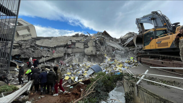
Two major earthquakes occurred on February 6 in Kahramanmaraş. The earthquake showed its effect in 10 provinces and caused the destruction of many flimsy buildings and areas. After the earthquake, many places changed in the Southeast Anatolia and Mediterranean region on the map of Turkey. So, how did the map of Turkey take shape after the earthquake? Let’s take a look at the details of the news together.
Turkey map changed after Kahramanmaraş-centered earthquake
Kahramanmaraş-centered earthquakes affected a large area two times in a row at the same time. As a result of this effect, many areas in Turkey were almost destroyed. Although the snow did not show every area in detail due to the fact that the earthquake took place in the winter months, significant changes in other places drew attention.
Due to the earthquake, 350 km of the East Anatolian Fault Line and 150 km of the Çardak Fault Line were affected. An area of 250 km on the Eastern Anatolian Fault Line was broken during the earthquake. The images that emerged thanks to the satellite shots revealed the changes.
A aid broadcast will be made with the participation of all Turkey!
President Erdoğan announced the broadcast of Turkey One Heart, which will be attended by 8 channels. Here are the details…
On the other hand, the fact that the second earthquake had great effects on Hatay is due to the fact that the ground structure of the region changed after the first earthquake. After the first earthquake, Hatay experienced soil enlargement and therefore suffered great damage in the second earthquake.
The Kahramanmaraş earthquake is among the biggest earthquakes in the 21st century. However, it is not possible to compare the effects of the earthquake with other earthquakes for now, since it is very recent.

To see the current post-earthquake map of Turkey, you can go to atlas.harita.gov.tr and review it. Base map, aerial photographs, topographic and satellite (earthquake) maps are available on this website.
What do you, our readers, think about this issue? How long do you think the effects of Kahramanmaraş earthquake will recover? You can express your views in the Comments section.